Spatial Data Management
State-of-the-art
Hub4Everybody platform
The PoliRuralPlus project utilises the Hub4Everybody framework (for more information visit Hub4Everybody) to develop a comprehensive web portal tailored to the needs of all participants. CCSS and Plan4All are part of the consortium that has been developing this framework. Hub4Everybody provides a versatile platform for creating web-based knowledge hubs supported by spatial data. This unique platform facilitates the publication, sharing, and collaborative management of geographical datasets, including professional data, research results, educational materials, and visualization tools.
Within the scope of the PoliRuralPlus project, spatial data from project partners will be stored and shared using the Hub4Everybody platform. This system allows easy uploading and updating of data, with customizable sharing settings to accommodate different audiences.
Hub4Everybody serves as an alternative solution by combining online office software with an editorial system for spatial data. It offers an open-source alternative to existing commercial solutions, along with additional extension options.
The platform includes standard geoportal functionalities such as map interaction and external data linking. Additionally, it enables seamless integration with desktop and mobile geographical data processing solutions, data visualization in storyboard format, and communication via social networks.
Hub4Everybody also features an e-learning module that allows editors to create extensive e-learning courses, complete with quizzes and certificate generation. This enhances the educational aspect of the platform, making it easy to create and disseminate educational content efficiently.
Scalable and fully adaptable, Hub4Everybody can store data either in its cloud or within the user's infrastructure. Moreover, all technologies used in Hub4Everybody are open source, facilitating global communication without any associated costs.
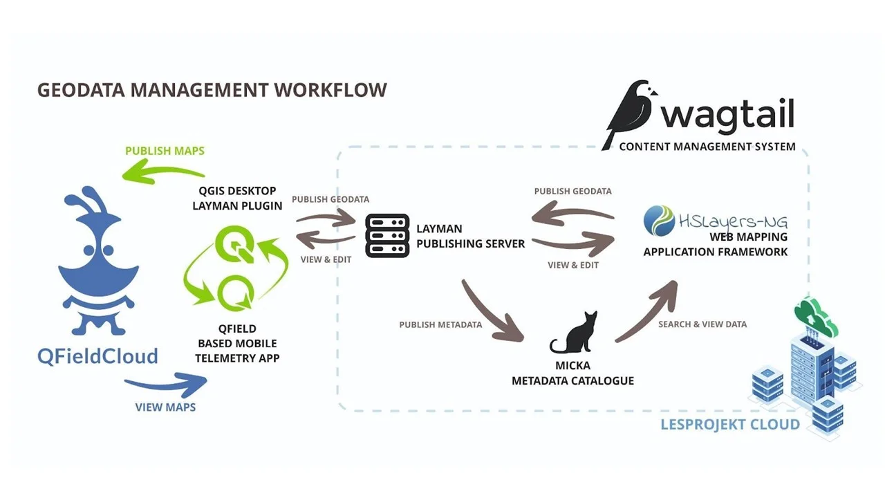
Figure 1 (above) shows the main technical architecture of the Hub4Everybody framework. It includes:
- Content management system (CMS) Wagtail: serves as the foundation for the entire framework, offering all the tools needed by the portal’s editors;
- LayMan server: manages the publication of spatial data in the form of OGC-compliant web mapping services (visit Standards - Open Geospatial Consortium);
- Web mapping client: developed on top of the HSLayers-NG framework (visit HSLayers NG);
- Desktop client: available as a plugin for the popular open-source GIS software, QGIS (visit QGIS);
- Mobile clients: available as native apps derived from the QField project (visit QField);
- Metadata catalogue Micka: stores all the descriptive information of the published data, offers extensive search capabilities, and serves the data in standard catalogue service (visit Catalogue Service - Open Geospatial Consortium for details).
PoliRuralPlus objectives for extension
The extended objectives include implementing state-of-the-art 3D visualization tools within the Hub4Everybody platform to enable dynamic representation of geographical data. This provides users with immersive and interactive experiences, crucial for detailed geographical analysis and educational purposes.
Additionally, the platform will facilitate direct integration with Jupyter Notebook, allowing users to perform complex data analysis through this versatile computing notebook interface. This integration aims to support real-time data manipulation and visualization, enhancing the platform’s utility for scientific research and advanced spatial data analysis.
Advanced AI tools will also be integrated to automate the analysis and interpretation of spatial data. This includes deploying machine learning models for predictive analytics, pattern recognition in geographical information, and optimizing data-driven decision-making processes. These AI tools will enhance user interaction with the platform, providing a more responsive and intuitive user experience.
The platform’s capability to connect with various external data sources and APIs will also be enhanced, facilitating a broader data integration that supports a more comprehensive data analysis environment. This allows the platform to serve not only as a data repository but also as a central hub for data-driven insights and collaborations.
User interface and experience improvements will be undertaken to support the new functionalities, particularly the interactive elements associated with 3D visualizations and AI tools. The aim is to ensure that the platform remains user-friendly and accessible to all users, regardless of their technical expertise.