

A Modern Approach to Mapping Innovation
In today's data-driven world, having detailed, current information about a region’s innovation potential is crucial for smart planning and investment. A recent study published in the ISPRS International Journal of Geo-Information introduces a new way of assessing this potential using open spatial data. The core of this methodology is built on the work of the PoliRuralPlus project, which provided both the testbed and the broader context for implementation.
Moving Beyond Traditional Methods
Conventional methods for evaluating innovation potential often rely on national or regional statistical data. While these approaches offer useful summaries, they tend to overlook the diversity within regions. As a result, they may miss key factors like the presence of research institutions or technology hubs in specific localities.
To solve this, the research team used data from OpenStreetMap (OSM), a globally available and community-maintained spatial dataset. Thanks to its openness and level of detail, OSM allows researchers to pinpoint important infrastructure elements like universities, research centers, and data hubs. When combined with geographic information systems (GIS) tools, this data enables much more precise spatial analysis.
The Role of PoliRuralPlus
The PoliRuralPlus project played a central role in shaping and testing the new methodology. As a continuation of the original PoliRural initiative, it supports smarter connections between rural and urban areas through advanced digital tools such as artificial intelligence, IoT, GIS, and data analytics. The project's goals include promoting green and circular economies, reducing regional inequalities, and fostering collaboration across sectors.
The project features nine pilot regions across Europe, including areas in Slovakia, Ireland, Italy, Latvia, Greece, Finland, Spain, Malta, and the Czech-Bavarian border. These pilots were used to apply and validate the OSM-based method for assessing innovation potential.
Key Findings
The analysis revealed large differences in innovation potential between densely built urban centers and more sparsely populated rural areas. Capital cities and regional hubs scored highest, primarily due to the concentration of innovation-driving infrastructure. On the other hand, rural areas tended to show low innovation potential, even though many have untapped opportunities for development.
One standout example was eastern Bavaria. Despite being largely rural, the region scored high thanks to strategic support for innovation infrastructure, such as the development of university campuses and transport connections in smaller towns.
This level of spatial detail would not be visible using traditional aggregated data, which often treats entire administrative regions as uniform blocks. The OSM-based approach allows for pixel-level analysis, which better reflects real differences and helps policymakers target specific locations for development.
Looking Ahead
The study highlights the benefits of using open spatial data and flexible digital tools. It also points out areas for future improvement, including the integration of OSM data with official statistics and other sources like commercial or volunteered geographic information.
Thanks to its adaptability, the methodology can also be applied to other forms of spatial evaluation, such as mapping economic potential, tourism, or quality of life. It offers value to many stakeholders, including regional planners, public administrators, investors, and communities.
The PoliRuralPlus project continues to develop and refine these tools. The next steps include optimizing data models, testing predictive scenarios, and building web applications for broader access. These advances aim to support better decision-making and contribute to more balanced regional growth across Europe.
Conclusion
Using OpenStreetMap and geoinformation technologies to assess innovation potential marks an important step toward smarter, more inclusive regional planning. The PoliRuralPlus project has been instrumental in demonstrating how this can work in real-world settings, across diverse European regions.
This open and flexible approach offers a practical tool for anyone working to support innovation and sustainable development, especially in rural areas that are often overlooked by traditional evaluation methods.
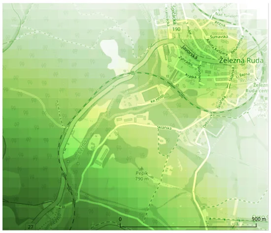
Figure: Detailed view showing a part of the pilot area on the border of Czechia and Germany.
"Čerba, O. (2025). OpenStreetMap as the Data Source for Territorial Innovation Potential Assessment. ISPRS International Journal of Geo-Information, 14(3), 127. https://doi.org/10.3390/ijgi14030127"

Existing Comments