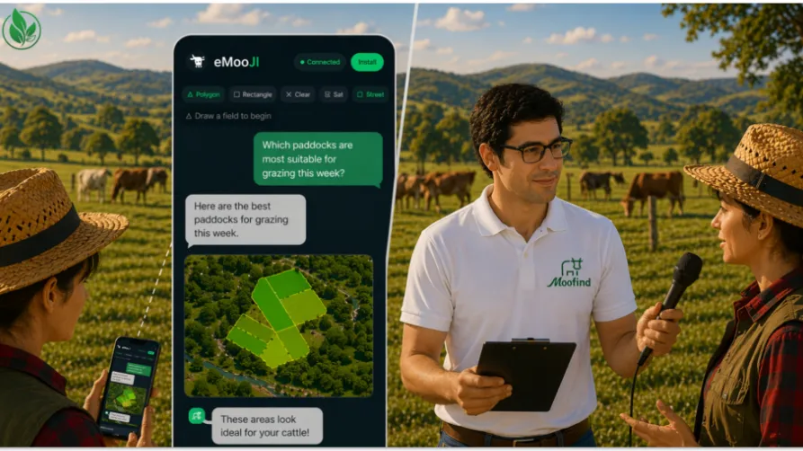
eMooJI is Moofind’s validation project under the PoliRuralPlus ENHANCE Call, testing how JackDaw can make complex spatial data easier to use for farmers and rural stakeholders. By combining GeoAI, Earth Observation data, GIS layers, and retrieval-augmented generation, JackDaw turns natural-language questions into location-specific insights for grazing and land management. eMooJI extends this with a dedicated multilingual chat interface in English, Spanish, and German, including dark mode, voice interaction, and session recording. Through real-world validation in Germany, Scotland, and Spain, the project assesses usability, reliability, and practical relevance for non-technical users.
Why does spatial data matter in grazing and land management?
Grazing and land management decisions depend heavily on understanding the landscape. Farmers and land managers regularly need to assess:
- Pasture condition and vegetation health
- Grazing suitability across different areas
- Slope and accessibility of land
- Risks such as erosion or heat stress
- Protected zones, such as Natura 2000 areas
- Changes in productivity over time
This type of information is increasingly available through satellite data and digital mapping tools. Yet, despite its potential, it is often underused in daily practice.
In many cases, decisions are still based on experience, observation, or manual planning methods. While these approaches are valuable, they can be complemented by data-driven insights—if the tools are easy enough to use.
What is JackDaw, and how does it help users query map layers and EO-related information?
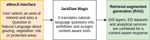
JackDaw is a spatially enabled GeoAI chat agent that combines large language models with geospatial data, domain tools, and a retrieval-augmented generation (RAG) layer to deliver location-specific answers. Unlike standalone LLMs, which mainly rely on general knowledge, JackDaw bases its responses on local spatial intelligence and trusted external sources.
Technically, the system translates natural-language questions into workflows across GIS layers, Earth Observation datasets, and specialised analytical services. A key feature is tool pre-filtering: JackDaw exposes only connectors whose topical, temporal, and spatial metadata match the query, thereby improving both precision and efficiency.
Its LangChain-based orchestration then combines lightweight NLP steps, foundation-model reasoning, and domain-specific kernels as needed. The result is a more traceable, context-aware system that can retrieve, analyse, and explain map-based information in a form usable for real agricultural and rural planning decisions. The JackDaw’s capabilities are enhanced by connecting Model Context Protocol(MCP) servers, which provides a structured way to expose additional tools and data connectors to the system. For a system like JackDaw, this is especially useful when different users or regions require access to different datasets, models, or planning functions. Thus making the architecture more modular and scaleable.
In short, JackDaw interprets the intent of the query, identifies the relevant datasets (e.g. vegetation indices, land-use layers, protected-area boundaries) or tools, and retrieves the corresponding spatial information. The results are then presented in a visual and interpretable format, typically combining maps with summarised explanations. The datasets and tools can be added to the So From a technical perspective, this involves:
- Query understanding, where natural language is parsed into spatial and temporal constraints
- Data orchestration, linking multiple geospatial data sources such as EO imagery, terrain data, and land-use classifications
- Context-aware reasoning, where the system adapts responses based on location, time, and user intent
- Output generation, translating map information into concise textual summaries
This approach reduces the need for users to understand underlying data structures or GIS workflows.
What is eMooJI and what are its objectives?
eMooJI is Moofind’s validation project under the PoliRuralPlus ENHANCE Call, funded by the European Union’s Horizon Europe programme. The project is focused on testing JackDaw in real-world agricultural and landscape management contexts across Germany, Scotland, and Spain.
Rather than developing new technology from scratch, eMooJI focuses on validation: understanding what works, what does not, and how the tool can be improved based on real user feedback. Its core objective is to evaluate whether conversational GeoAI can make spatial data more accessible, useful, and actionable for non-technical rural users.
As part of the project, MooFind has developed a dedicated chat interface that consumes the JackDaw APIs, extending the tool’s human–machine interaction capabilities beyond the base system. The web app is available at https://emooji.moofind.com. The interface has been designed to support more inclusive and practical field use, with key additions including a multilingual interface (English, Spanish, and German), dark mode, voice interaction, and session recording.
In this way, eMooJI is not only validating JackDaw’s analytical value but also improving the way users access and interact with it under real-world conditions.
How will eMooJI assess usability, reliability, and relevance?
A key part of the project is understanding how users interact with the tool and how useful it is in practice. The validation process combines several methods. First, users are introduced to the tool through workshops and training sessions. Then there will be guided and independent testing, allowing participants to explore real use cases. Then, through surveys, interviews, and feedback forms, deeper insights into user experience shall be gathered. The project aims to analyse both quantitative data, such as usability scores, and qualitative feedback such as user comments, suggestions and observations of how questions are framed.
By comparing results across regions and stakeholder groups, eMooJI aims to identify common challenges, strengths, and opportunities for improvement.
Further Read
- Bridging Global Language Models and Local Spatial Data: The JackDaw Approach to Context-Aware Agriculture and Rural Planning - http://dx.doi.org/10.15439/2025F8393
- Model Context Protocol - https://en.wikipedia.org/wiki/Model_Context_Protocol


Existing Comments