Why FloodAI+ matters now
Flood-risk information is becoming richer, more spatial and more data-driven. Hazard layers, satellite imagery, exposure models, vulnerability indicators and rainfall scenarios can now describe flood risk with increasing detail. But for many local actors, the most important question remains practical: what does this mean for my place, my assets and my next decision?
This is the gap that FloodAI+ is designed to address. The project validates and enhances JackDaw, the PoliRuralPlus GeoAI chatbot, as a multilingual conversational interface for flood-risk information. Instead of asking users to navigate complex geospatial datasets on their own, FloodAI+ explores how conversational AI can help translate maps, models and spatial summaries into clearer, more usable answers.
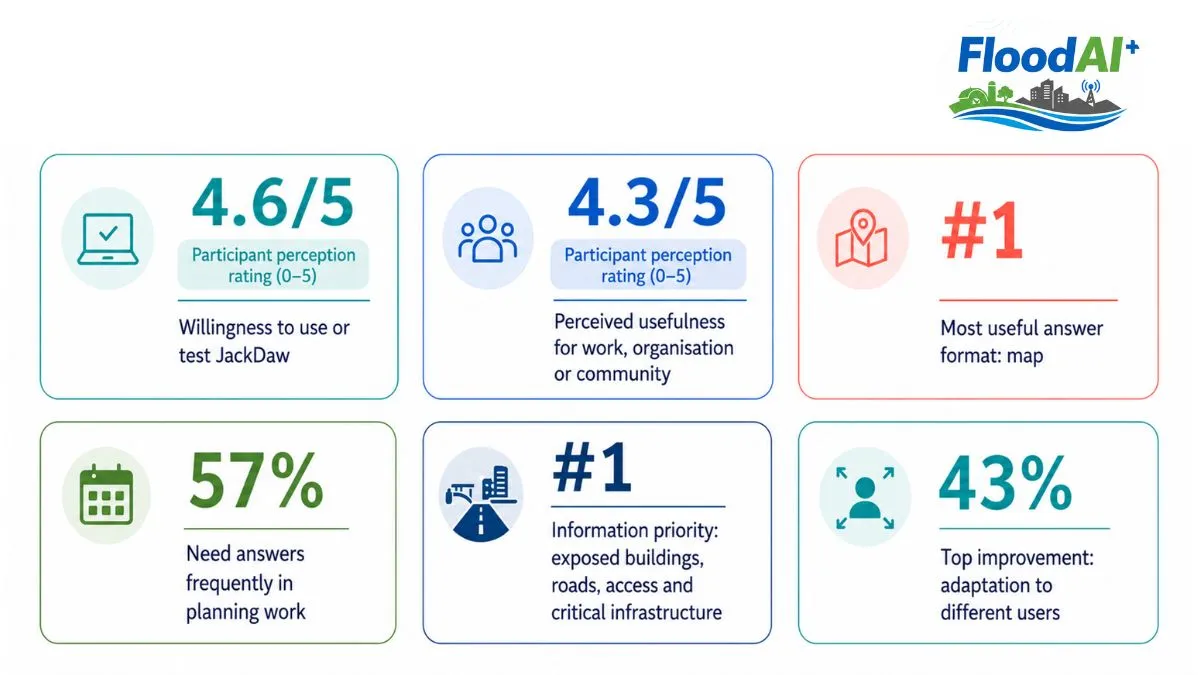
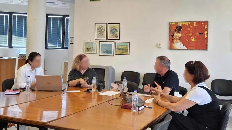
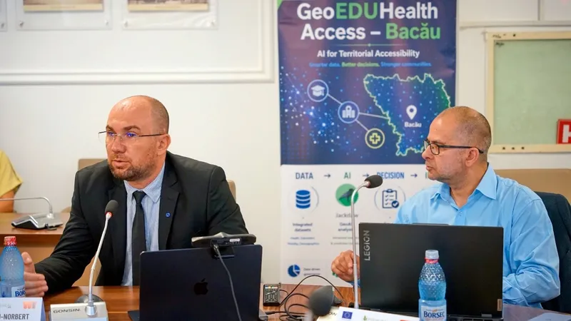
The first workshop marked an important step in that validation journey (Figures 1 and 2). Participants explored how JackDaw - now supported by the new Flood Connector - could help interpret flood-risk information for real stakeholder needs, from municipal planning and infrastructure protection to emergency preparedness, agricultural continuity and community communication.
The early feedback points to a clear direction: stakeholders are not simply asking for more data. They want flood-risk information that is visual, understandable and connected to action. In other words, they want tools that can help turn flood maps into decisions.
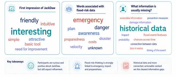
Figure 2 – Word-cloud insights: open-text feedback highlights how participants perceive JackDaw, how they think about flood-risk data and what information they still need.
A workshop with a strong signal
The participant group was compact, but intentionally diverse (Figure 3). Municipalities represented the largest share of responses, followed by infrastructure managers, SMEs and research or academia. This matters because flood resilience is never a single-sector challenge. It connects planning departments, road and utility operators, farmers, emergency teams, researchers and citizens.
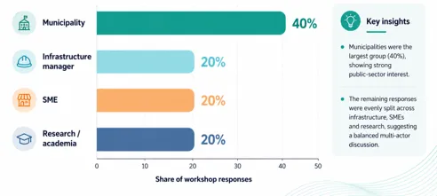
Figure 3 – Who joined the first validation Workshop?
When asked what kind of flood-risk decisions JackDaw should support (Figure 4), infrastructure protection emerged as the strongest priority. Emergency planning, land-use or agricultural planning and other decision needs also appeared, confirming that JackDaw must serve both operational and strategic use cases.
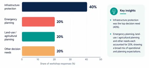
Figure 4 –The decisions that participants want JackDaw to support.
What users want first: maps that explain risk
When participants were asked what type of answer would be most useful from JackDaw, the answer was clear: maps came first. But the message behind that result was more interesting. Stakeholders were not asking for maps alone. They were asking for maps that explain risk, connect to local decisions, and make uncertainty easier to understand.
Participants then ranked risk summaries, short text explanations and comparisons between areas as the next most useful answer types (Figure 5). This is an important validation result for FloodAI+: users do not want a chatbot that replaces maps; they want a chatbot that makes maps easier to understand.
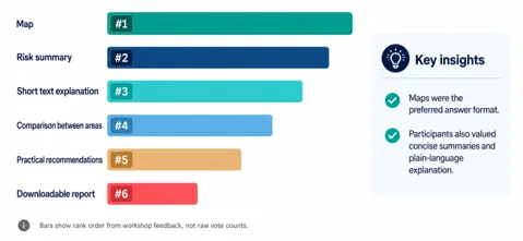
Figure 5 – Rank order from participants’ feedback about the most useful answer types.
That means JackDaw’s value lies in combining three layers of support: spatial evidence, plain-language explanation and decision relevance. The information priorities reinforced this point. The highest-ranked flood-risk information (Figure 6) was exposed buildings, roads, access routes and critical infrastructure, followed by hazard zones and vulnerable populations. Participants were not only asking “where is the flood?” They were asking “what is exposed, who is vulnerable, and what could be disrupted?”
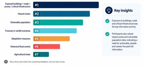
Figure 6 – Rank order from participants’ feedback about flood-risk information that mattered most.
The questions were practical, local and urgent
The open responses gave the most vivid insight into user needs. Participants asked whether they were living in a safe zone, which areas were affected by floods, what maximum flow depth and velocity were detected, what the outlook could be for the next 10, 30 or 50 years, whether a farmer could safely work in a field, and what prevention measures could protect critical infrastructure.
These questions show that stakeholders need JackDaw to work across several levels at once: individual safety, household decisions, business investment, infrastructure protection, agricultural continuity, future scenarios and public communication.
They also show why the Flood Connector is so important. To answer these questions credibly, JackDaw needs to connect natural-language prompts to real flood layers, spatial summaries, exposure indicators and uncertainty information. A good answer must be conversational, but it must also be grounded in data.
What is missing today: historical data and actionable context
When participants were asked what information is usually missing when they try to understand flood risk, the dominant answer was historical data. Other missing elements included accessible information, prevention measures, damage information, flood-event features, probability, losses in euros, timing of events and connections between datasets.
This is one of the most useful findings for the next phase of validation. It suggests that stakeholders do not only need current hazard zones. They need a storyline: what happened before, how impacts evolved, what damages occurred, how likely similar events are, and what measures can reduce losses.
“Users do not want a chatbot that replaces maps; they want a chatbot that makes maps easier to understand.”
Encouraging ratings, but a clear improvement agenda
The ratings from the first workshop were encouraging. Participants rated JackDaw’s usefulness for their work, organisation or community at 4.3 out of 5, and the desire to use or test JackDaw at 4.6 out of 5. This is a strong early signal: people see value in the concept and want to continue testing it.
At the same time, the workshop showed where the tool must improve. The answers were rated 3.7 out of 5 for being easy to understand and 3.3 out of 5 for relevance to flood-risk information. The lowest score, 2.9 out of 5, concerned usefulness for decision-making or communication (Figure 7).
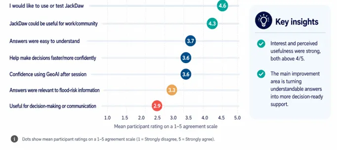
Figure 7 – Participants’ ratings on a 1-5 scale.
This difference is important. It tells us that JackDaw is already interesting and understandable, but it still needs to become more decision-ready. Users want answers that are not only clear, but tailored, grounded, visual and confident about uncertainty (Figure 8).
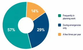
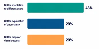
Figure 8 – Expected frequency of use and priority areas for improving JackDaw.
From “interesting tool” to trusted flood-risk mediator
Participants described their first impression of JackDaw with words such as interesting, friendly, simple, intuitive and attractive. But they also used phrases such as basic tool and need for improvement. This is exactly the kind of honest feedback FloodAI+ needs.
The project is not validating JackDaw in the abstract. It is validating whether JackDaw can become a trusted mediator between complex geospatial data and everyday flood-resilience decisions. The first workshop suggests that the direction is promising, but the validation must now focus on four practical improvements: user-specific explanations, better maps and visual outputs, clearer uncertainty cues, and more actionable answers for exposed assets, infrastructure protection, emergency planning and future scenarios.
What happens next?
The workshop confirmed that FloodAI+ is addressing a real need. Stakeholders want a tool that can help them ask better flood-risk questions, interpret spatial data faster and communicate risk more confidently.
In the next phase, the FloodAI+ team will consolidate the workshop results into the validation workflow for JackDaw. The findings will inform stakeholder-specific explanation templates, the multilingual flood-risk glossary, user journeys, visual outputs and the roadmap for the Flood Connector.
The first workshop was more than a demonstration. It was the first validation checkpoint. It showed that the future of GeoAI for flood resilience will not be built only by improving algorithms. It will be shaped by the questions people actually need to ask. FloodAI+ is helping JackDaw listen to those questions and turning flood-risk data into decisions.
This project has received funding from the European Union's Horizon Europe research and innovation programme PoliRuralPlus.
PoliRuralPlus has received funding from the European Union’s Horizon Europe research and innovation programme under Grant Agreement No. 101136910. Views and opinions expressed are however those of the author(s) only and do not necessarily reflect those of the European Union or the European Research Executive Agency. Neither the European Union nor the granting authority can be held responsible for them.
Existing Comments