The Context: Why Bacău County?
The GeoEDUHealth Access – Bacău project is implemented by MEDIA TREND SRL as the only Romanian company selected under the ENHANCE cascade funding call within the PoliRuralPlus Horizon Europe programme. The project validates the JackDaw GeoAI platform, developed by the Czech Technical University in Prague, in the specific context of Bacău County, a predominantly rural territory in north-eastern Romania facing significant disparities in access to education, healthcare, and transport infrastructure.
With approximately 70% of its population living in rural areas, Bacău County presents a compelling test environment for GeoAI validation. Dozens of communes are located more than 30 minutes by road from the nearest hospital, secondary school, or administrative center. Traditional GIS tools have been used to map these disparities, but they require specialist expertise and produce static outputs that are difficult to translate into actionable policy recommendations. JackDaw's ability to respond to natural language queries and simulate accessibility scenarios in real time represents a fundamentally different approach to this challenge.
Phase 1: Data Preparation and Ingestion
The first phase of the project focused on the preparation and ingestion of geospatial datasets into the JackDaw platform via the Raven data catalog. Datasets were collected from four institutional sources: the Bacău County Council (administrative boundaries and road network), the County School Inspectorate (school locations and enrollment data), the Bacău Public Health Directorate (healthcare facility data), and OpenStreetMap (supplementary points of interest). All datasets were cleaned, standardized, and converted to GeoJSON format (SRID 4326) before ingestion. A Python-based geocoding workflow using the Nominatim service was developed to geolocate institutional data available only in tabular form. Preliminary ingestion tests confirmed that all five datasets were successfully loaded and configured in the Raven platform, with correct metadata, semantic types, and spatial coverage.
Phase 2: Technical Validation and Benchmark Testing
The second phase focused on validating JackDaw's accuracy against classical GIS tools. Twelve test scenarios were run across three domains: healthcare accessibility (isochrone analysis for emergency services), educational planning (school transport optimization), and infrastructure investment prioritization. JackDaw's outputs were compared with equivalent analyses produced in QGIS using OpenRouteService isochrones. The results confirmed that JackDaw produces spatially accurate outputs consistent with classical GIS analysis, while significantly reducing the time and expertise required to generate them. Key challenges identified included the need for more granular road quality data and the importance of precise query formulation to obtain reliable results.
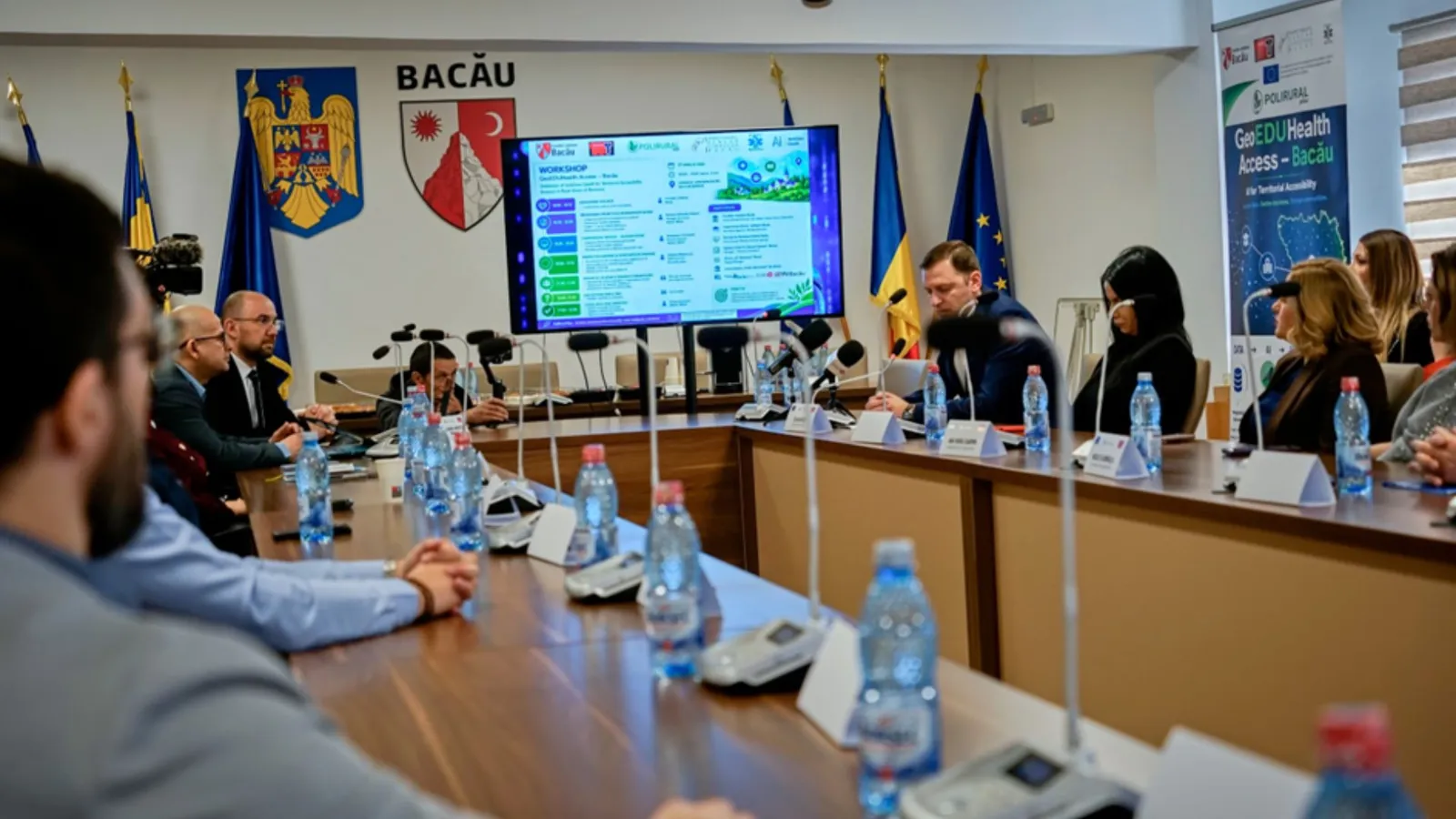
Phase 3: Stakeholder Validation Workshop
On April 27, 2026, MEDIA TREND organized the first stakeholder validation workshop at the Bacău County Council headquarters. The event brought together 18 participants from public administration, healthcare, education, academia, and the private sector, including representatives from the County Council, the County School Inspectorate, the Public Health Directorate, Hospital Buhuși, the Centre for Inclusive Education, and Vasile Alecsandri University of Bacău.

Alexandru-Norbert Droiman presenting the GeoEDUHealth Access project context and European positioning.
Participants were introduced to the platform through a series of live scenario demonstrations. An important aspect emphasized during the workshop was the current stage of the product: JackDaw is in an active testing and validation phase, and the quality of results depends significantly on the quality of the ingested data and on the user's ability to formulate clear, structured queries. Participants understood and appreciated this transparency, and were genuinely impressed by the breadth of potential applications.
Concrete scenarios demonstrated during the workshop included complex queries such as: "If an ambulance departs from Bacău municipality, how many communes cannot be reached in less than 30 minutes, ordered by population?", "How many students in Bacău County travel more than 30 minutes daily to the nearest secondary school, and in which communes are they concentrated?", and "Which segment of the county road network, if modernized, would reduce student isolation the most?" All scenarios were run using real accessibility isochrones calculated via OpenRouteService, accounting for the actual road network, terrain, road quality, and speed limits.

Constantin Avrămescu presenting the JackDaw GeoAI technical component and isochrone scenario demonstrations.
Stakeholder Voices
Through this integrated approach, Bacău County consolidates its position as a pilot territory in the intelligent use of technology.
We are testing in Bacău a data-driven, results-oriented working model that can later be replicated in other territories in the European Union, contributing directly to reducing territorial disparities between urban and rural environments.
For us, artificial intelligence has become not just an aspiration, but a necessity.
We must all become aware of the utility of AI-based tools, which can add significant value to improving the quality of public services.
For Bacău County, this project means more than a technological test – it is a concrete step towards a data-driven administration and decisions grounded in an advanced AI instrument.

Stakeholder feedback session: participants from healthcare, education, and public administration sharing their perspectives.
Key Feedback and Feature Requests
The workshop generated concrete and actionable feedback from domain experts. Adrian Gabor, Director of the Centre for Inclusive Education, highlighted the need to include data on the geographical distribution of children with special educational needs (SEN), enabling more targeted planning of support services across the county. Cristi Apetri, Director of Ardeoani Secondary School, requested that school network data be made queryable in relation to the upcoming academic year's curriculum plan.
Researchers from Vasile Alecsandri University suggested that it would be both interesting and useful to incorporate data as close to real-time as possible, for instance live traffic conditions. Constantin Avrămescu explained that this is theoretically achievable, either through a standard API integration or, more elegantly, through the connection of JackDaw to an established or customized MCP (Model Context Protocol) server. The advantage of the MCP approach, he noted, is that JackDaw can decide dynamically when to request external data based on the actual context of the user's query, rather than making continuous or scheduled API calls, making the integration both more efficient and more intelligent.

Open discussion session: participants exploring JackDaw's potential applications for their institutions.
What These Findings Mean
The workshop confirmed that JackDaw has strong and genuine relevance for public decision-making in a rural Romanian context. The platform's ability to answer complex spatial questions in natural language, without requiring GIS expertise, was consistently highlighted as its most transformative feature. At the same time, the validation process has surfaced important areas for improvement, particularly around data granularity, map visualization of query results, and the development of digital competencies among institutional end users.
Bacău County is the only Romanian territory piloting this GeoAI solution, and MEDIA TREND is the only Romanian company selected under the ENHANCE Call. The project contributes directly to EU priorities in digitalisation, evidence-based policy making, and the reduction of rural-urban territorial disparities, positioning Bacău County as an emerging hub for data-driven public policy innovation in Eastern Europe.
Next Steps
The project team is currently integrating the collected feedback into ongoing communication with the CTU Prague development team. The next steps include MCP integration testing with local and external data servers (May 2026), the expansion of datasets with additional local sources, and the development of the final Policy Report with concrete recommendations for Bacău County authorities. The second and final validation workshop is planned for June 2026.
Stay tuned for the next update as we continue to refine and validate GeoAI tools for rural territorial development in Romania.

Existing Comments