What happens when a rural territory has exceptional heritage assets, active local businesses and committed organisations, but the information connecting them remains fragmented? This was the question behind ARISE - Archaeological Routes for Inclusive Synergy & Entrepreneurship in Sierra y Mancha Conquense - developed within PoliRuralPlus.
Sierra y Mancha Conquense is home to major Roman sites, including Segóbriga, Valeria and Ercávica. These sites give the area a strong cultural identity, but visitors have often had to rely on separate websites, brochures and informal sources to understand what to visit, how to combine several locations and which rural services are available nearby. Territorial actors also lacked a shared digital environment for coordinating content, initiatives and monitoring.
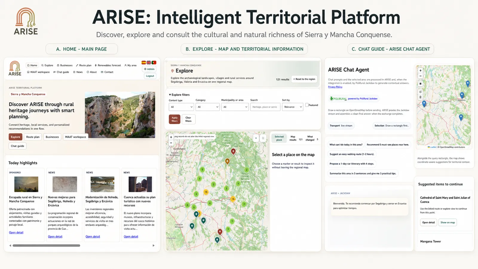
ARISE addressed this challenge by creating a Heritage Synergy Platform rather than a stand-alone tourism page. The public service at https://arise.xilbi.com/ connects map-based discovery, points of interest, rural businesses, route planning, territorial news, funding opportunities, saved itineraries and location-aware conversational guidance. The interface is available in Spanish, English and Portuguese and is designed to help visitors move from initial discovery to a practical multi-stop journey.
The ARISE Chat Agent, powered by PoliRural Jackdaw, illustrates the connection between geospatial information and conversational guidance. Users select an area on the map before asking a question. The selected geometry is processed through the ARISE backend so that the response remains linked to the territory while service credentials and technical configuration remain protected.
The project also recognised that a public interface alone would not solve the underlying coordination problem. Behind the visitor experience, ARISE includes an administration environment for businesses, routes, news, funding, promoted content and integrations. It also includes an authenticated MAAT workspace for stakeholder records, initiatives, tasks, route co-design, shared information, KPI monitoring and New European Bauhaus indicators. The result is a platform that links what visitors see with the operational work required to maintain and improve the territorial offer.
Final monitoring confirmed that all nine approved KPIs were met or exceeded. Forty-eight stakeholders were registered in MAAT and 63 rural businesses were represented on the platform. Monthly unique visitors reached 1,286, while active sessions averaged 5 minutes and 18 seconds. User satisfaction reached 4.4 out of 5. The platform recorded 148 planned itineraries and 17 collaborative planning or workspace sessions. Five structured dataset packages covering businesses, points of interest, routes, news and events, and audiovisual resources were prepared for PoliRuralPlus-oriented reuse, comprising 199 reviewed territorial records. The digital-first information model produced an estimated saving of 138 kg CO₂e compared with printed brochures.
These numbers are important, but the project also generated less visible lessons. A rural digital service needs more than a map and a collection of pages. It needs credible local content, clear language, reliable links, appropriate images, privacy-aware contact mechanisms, secure integration management and tools that authorised operators can actually use. ARISE therefore invested in multilingual completeness, rights-cleared imagery and provenance, public legal and privacy information, content administration, controlled access and repeatable quality assurance.
The final documented QA baseline includes 94 automated tests and 1,007 assertions. These tests cover public navigation, businesses, routes, news, funding, Jackdaw interaction, stakeholder functions, APIs, administration, privacy, contact flows, image handling and public indexing. Manual review remained equally important for layout, language, image relevance and overall credibility. This combination helped the project move from a functioning prototype to an operationally maintainable pilot service.
ARISE also demonstrates a broader PoliRuralPlus contribution. It applies Jackdaw-supported guidance and multi-actor collaboration to a cultural-heritage context, connects rural-business visibility with route planning and maintains structured information that can support future territorial analysis. The project shows that rural digitalisation can combine visitor services with governance and operational continuity rather than treating them as separate problems.
The New European Bauhaus principles are visible across the final result. Sustainability is supported through digital-first communication, route planning and reusable technical components. Inclusion is supported through multilingual public access, stakeholder participation and privacy-aware interaction. Aesthetics are reflected in a coherent visual identity, heritage imagery, map-led storytelling and a public interface that presents cultural assets and rural services as part of one territorial experience.
Replication was considered from the beginning. The final ARISE architecture, database structure, APIs, administrator guidance, localisation resources, integration notes and validation procedures provide a basis for independent deployment. The public software distribution is available through GitHub and is separate from the live production service: it excludes the production database, personal data, stakeholder records, credentials and environment-specific configuration. A new rural territory can adapt the platform by replacing geospatial layers, heritage records, business information, routes, news and funding sources, branding, languages and stakeholder roles. The principal public, administrative and collaboration components can remain substantially unchanged.
This replication logic matters because the challenge addressed by ARISE is not unique to Sierra y Mancha Conquense. Across Europe, many rural areas contain valuable cultural assets and active local enterprises, but lack a coherent digital journey linking visitors, services and territorial stakeholders. ARISE offers a practical pattern for bringing those elements together without requiring each territory to start from zero.
The funded implementation period has now concluded, but the project result is designed to continue. The live platform remains the public ARISE service for Sierra y Mancha Conquense, while the reusable public software distribution and documentation support future adaptation. Continued value will depend on technical maintenance, current territorial content and sustained stakeholder involvement, but the essential foundation is now in place.
ARISE concludes with more than a demonstrator. It leaves a working digital service, a measurable evidence base, an operational multi-actor environment and a transferable model for heritage-led rural development. By connecting Roman heritage, rural businesses, visitors and territorial coordination, the project has shown how digital innovation can support stronger rural attractiveness and more coherent rural-urban relationships.
The ARISE platform is available at: https://arise.xilbi.com/
Project repository: https://github.com/obsi-org/ARISE
Funding acknowledgement
PoliRuralPlus has received funding from the European Union’s Horizon Europe research and innovation programme under Grant Agreement No. 101136910. Views and opinions expressed are however those of the author(s) only and do not necessarily reflect those of the European Union or the European Research Executive Agency. Neither the European Union nor the granting authority can be held responsible for them.
Existující komentáře